I first fell in love with Margaret River in the early naughties, when I’d happily skip a uni lecture for a day trip to find world-class waves. But it was its trail running that kept me returning to beautiful Margaret River, so much so that when I’d tired of sharing the trails with runners, hikers and bush walkers, I forged my own paths. Eventually, my mental list of secret running trails in Margaret River grew so long that I needed to share them with other runners.
And so, here are a few of those secluded trails in Margaret River, that’ll have you exploring terrain throughout the southwest region that most locals have never been.
5 secret running trails in Margaret River the locals don’t even know:
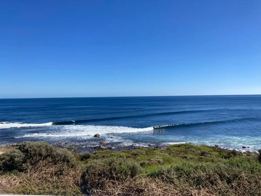
Gas Bay to Hollow Cave Road (loop)
I found this trail when the 2021 Grand Final bored me to tears (it was a whitewash) and I needed to get out of the house on a rainy day. My wife shook her head at me, the thought of heavy rain spearing her face on a trail run not exactly appealing to her—she convinced herself the game wasn’t that bad.
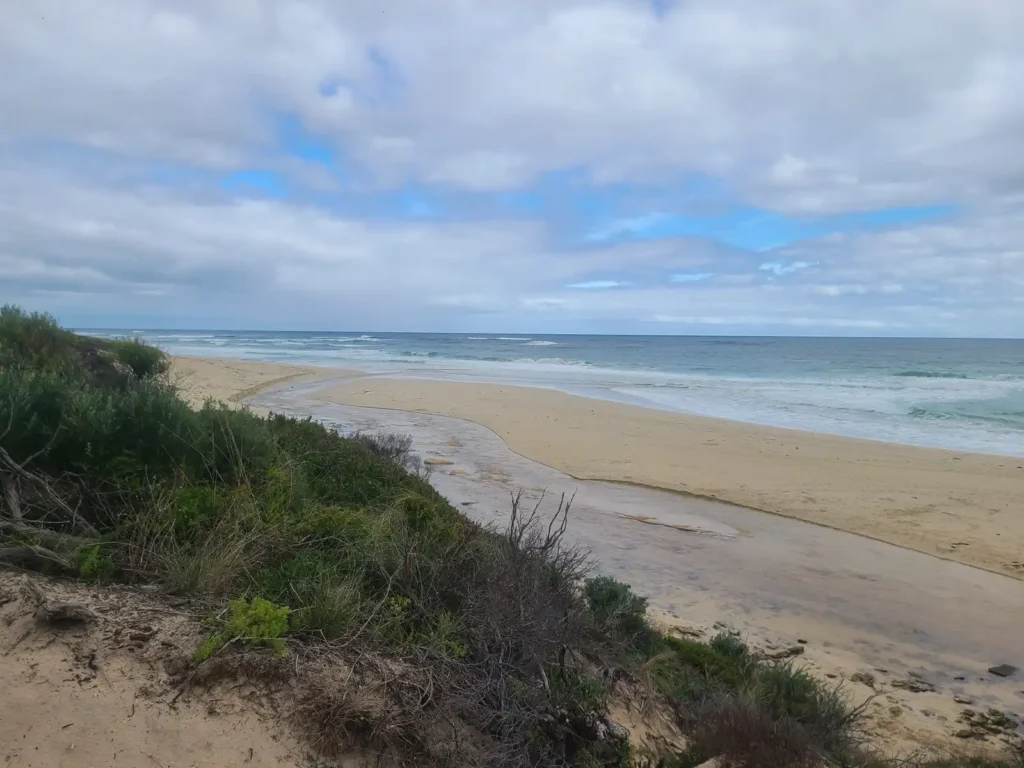
I parked up at Gas Bay, the wind blowing me sideways, and set off southbound from the carpark. It was freezing but I’d thankfully packed the right gear for my trail run, as impromptu as it was. When you follow the track toward the point, drop down to the beach until you see an option to head over the small ridge and off the sand. You’ll find something akin to a coastal slip road, all sand of course, which protects you from the onshore winds and gives you a view of the steep dunes on the left. They’re actually fun to tackle for some hill training.
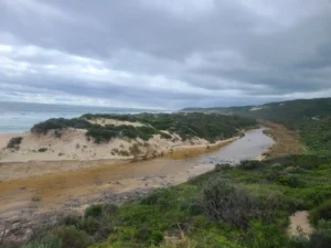
This slip road of ours will eventually put you back on Gas Bay’s long stretch of sand. You’ll get to the end of it after about 1km and be confronted either with a river mouth or the dried remnants of it, depending on the season you’re in. This is where it gets fun.
Follow the water until you’re forced to take your trail running shoes off (trust me, it’ll be worth it). On the other side of the stream is the Cape to Cape Track, and in fact, hikers will have a perfect viewpoint of you untying your shoelaces and reconsidering what the hell you’re doing. When you’re over the stream, climb up one of the several trails that lead you to the Cape to Cape trail. Then, head northward along the beautiful track. This is one of my favourite sections of the Cape to Cape, with stunning flowers, streams and coastal views on offer.
Eventually, you’ll get to a narrow steel bridge that takes you to a cosy clearing that’s reminiscent of Frodo Baggins’s front yard. Lilies everywhere, wildflowers, lush green grass, which I’d guess has seen the backs of many Cape to Cape hikers… It’s a stunning place for a break if you’re that way inclined.
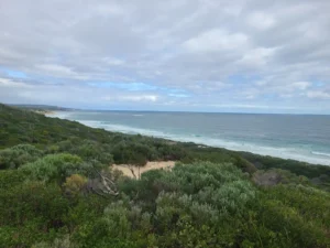
Stairs are next, and lots of them. When you get to the top, suck in a few big ones and then check out the gorgeous view of Gas Bay and all the beautiful green landscape in between. The sandy path will take you to a 4WD trail—Blackboy Hollow Cave Road (its name deserves a change)—which will guide you directly to the Gas Bay carpark. On one of my missions on this route, I’d met a concerned hiker who had little idea how to get to Gas Bay. I left a note for him to follow at the top of the stairs…
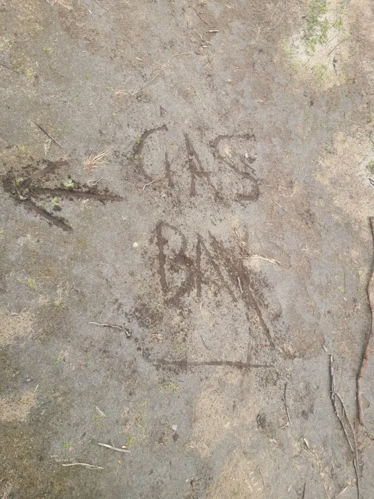
Incredibly, that night watching a band play at The River, I met the same bloke again. He’d found his way back to the car, all thanks to a little scribble in the dirt.
This route is only 4km-5km, but geez, it’s as cathartic as it gets. The option of sand dune climbs at the beginning of the hike would ramp up your distance and your heart rate, so feel free to make this secret trail run in Margaret River your own.
Ellensbrook Road to Gracetown (return)
This, like nearly every other of my secret Margs trail runs touches or is 100% on the Cape to Cape Trail. Pull up at the end of Ellensbrook Road, gear up in the carpark of popular surfbreak Umbies, and head north along the trail to Gracetown.
This section of the southwest’s longest trail run has all sorts of personalities, with waist-high bush following the rocky coastline, with views of that navy ocean slapping against the shores on offer for most of the run.
Get your free Cape to Cape Track Map here
Free to download, our beautifully designed map of the Cape to Cape Track, the southwest’s most premier and longest trail, is yours to download. No email required, just click here and enjoy digesting the best stops along the Cape to Cape Track.
Towards the end of the out leg, you’ll find choose-your-own-adventure-style terrain that somehow made me think of the surface of the moon. Huge limestone craters in a sandy valley, before a few sections on the beach and finally a hill climb up to the viewpoint of Gracetown. Enjoy a breathtaking view, you’ve earned it, before turning your back on the surfers at South Point and making your way back to Ellensbrook Road.
Redgate Beach to Bob’s Hollow (return)

I’m shocked that I haven’t seen anyone else on this trail run, considering how popular Redgate Beach is for Margaret River locals and visitors. It’s a beauty for both sand running, trail running and the ultimate clifftop views of the coastline.
Start at the Redgate Beach carpark (if you can find a spot amid all the surfers) and set out southbound. You may need to get the shoes off midway down the beach, if the Calgardup Brook is spilling out into the ocean, and wade through the water. At the end of the beach, ascend the Cape to Cape Track into the bush, hugging the trail right. As you follow the coast, the extremely rugged terrain of the trail will ensure your wits are about you, with so many rocks sticking from the hard-packed dirt and a tonne of undulating obstacles for you to navigate. Watch the ankles but also keep an eye out of the unbelievable views on your right.
Eventually, Bob’s Hollow Road will intersect with the Cape to Cape Track, and you’ll take the trail right again. A secluded beach will greet you and the optional dip on the return journey is highly recommended. Within 1km, the towering cliff faces of Bob’s Hollow are unmissable. The climb is brutal but rewarding, as there are a tonne of beautiful overhangs, caves and rock climbing routes to marvel at as you go for gold to get to the epic lookout.
You’ve made it to the northernmost part of Conto Beach, a deserted haven only accessible by foot or by 4WD. Enjoy the view and then head home the way you came. Or, why not stay the night at Conto’s Campground? The experience is epic, as we’ve explained in our post on the best overnight hikes in Margaret River.
Rotary Park to Darch Road (return)
This one includes two top Margaret River running and walking trails, the Ten Mile Brook Trail and the River Walk. Start at Rotary Park—along Bussell Highway and just south of the Margaret River Brewhouse—and follow Warperup Creek through the winding and scenic River Walk trail. It’s a dog-friendly route, so you’ll probably meet a few furry friends on the way.
The Ten Mile Brook Trail ends on the fringe of a suburban area, and by this point you’ll likely not have seen another soul for a good kilometre. Now, continue on the trail, which is now Darch Road, a dirt track with private properties on either side. This part of the route may not be as scenic as Ten Mile Brook Trail, but offers flat surfaces on a dirt trail, helping you achieve your distance goals (like it did for me). Once you hit Perimeter Road, turn back for Rotary Park.
This route offers plenty of river views, berms, tree cover and absolute solace while being only a couple of klicks from the heart of Margaret River township.
Wilyabrup trails
Known for its rock climbing, Wilyabrup is also a trail runner’s playground. The routes here are incredibly steep and undulating, and while not all that long, the Wilyabrup trails will be enough to turn your legs to jelly in under an hour.
Park at Wilyabrup Sea Cliffs Car Park, and follow the well-loved path over the fence (steps have been provided to help you) and coastbound towards the cliffs. Less than 1km away, you’ll find abseilers and rock climbers enjoying easily the most popular activity in these parts. If you set off north once you’ve hit the first set of cliffs, you’ll find some layers of trail that puts you in and around the neighbouring forest. It’s a hell of a trail run that not only offers the opportunity for great hill repeats up the many sets of stairs, but impeccable views of the rock climbers and abseilers nearby.
The beauty of Margaret River and the rest of the southwest in West Australia is there is so much unknown and unmapped running trails waiting to be explored (Much like their 4WD tracks. Check out our mission along Bob’s Track: the southwest’s most feared 4WD trail). If you want to pioneer your own route, you won’t be challenged—just pick a carpark or an accessible spot on Google Maps and head off on the huge network of trails that the Margaret River region is famed for.


