‘Have you hiked Mount Bruce yet?’ That was a common question at Dale’s Gorge campground. Mount Bruce (Punurrunha) in Western Australia is a big piece in the ultimate Karijini National Park puzzle, a stunning six-ish-hour return hike on a Class 5 summit trail with views that stretch as far as your eyesight does from its 1,234m-high peak.
With the whistle almost blown on our time in Karijini National Park, one of our last remaining activities was to get to the top of Mount Bruce. It was by far the biggest challenge on our Karijini experience, given we’d spent most of our time lazing in gorges and gently swimming through their tranquil waters.
Skip to:
Climbing Mount Bruce in Karijini National Park
And to be honest, you’d be a little foolish thinking it’s a simple stroll up a gradual incline, as if the only thing to steal your breath might be the magical views from the top. But Mount Bruce is nothing to sneeze at, with 9km of undulating trails getting you from carpark to the second highest mountain in West Australia. All that said, my now-fiancee Laura and I had a blast.
We were the only ones on the trail on a cool June morning, and I must say, getting our dust-covered shoes to the top was one of the best experiences in our time at Karijini National Park.
Pros and cons of hiking Mount Bruce
Pros:
- Incredible views of the Hamersley Range (Karijini)
- Multiple routes satisfying both experienced and novice hikers
- Beautiful views throughout the entire journey
- Second highest mountain in WA, ticked off your bucket list
Cons:
- Marandoo minesite echoes through valley in the early stages of the hike
- Heat between November to April is atrocious
The history of Mount Bruce
The first colonialist to set sight on Mount Bruce was Francis T. Gregory in 1861. Gregory named his find after the commandant of the WA Military Force at the time, Colonel John Bruce. But of course, Mount Bruce’s history extends far beyond that of the European history books.
Only 62km southeast from Mount Bruce stands WA’s tallest mountain, Mount Meharry. The close proximity of the pair makes you wonder about the growth pains this area must’ve had in its long history.
Like sands through the hourglass
The story of Mount Bruce begins 2.5 billion years ago, before the first tree sprung from the earth. The whole area that surrounds it was covered by shallow sea, where iron-rich sediments settled on the ocean floor, layer after layer. The pressure mounted over time eventually and turned these layers into the breathtaking coloured rock the entire national park is renowned for. You can even see those layers, and they seem to tell a story of the rock’s age, just like tree rings do inside ancient trees.
When sea levels eventually dropped, the land was sculpted into huge valleys, deep gorges and majestic mountains like Mount Bruce. So, the mountain was once at the seafloor, and incredibly during bouts of heavy rainfall the same sediment that acted as building blocks for Mount Bruce effectively returns to the ocean whence it came.
Cultural significance
The Indigenous Australian name for Mount Bruce is Punurrunha or Bunurrunha. For thousands of years, the mountain has been an important site for the Banyjima, Yinhawangka and Kurrama peoples, who’ve lived in and cared for this land long before roads and hiking trails were paved.
Punurrunha isn’t just a mountain to them—it’s part of their Dreaming stories, a place where ancestors left their songs and where spirits still walk. You’ll only add to your experience of Punurrunha by keeping this in your mind as you hike.
Profit over preservation
Karijini holds some of the richest iron ore deposits in the world. So, unsurprisingly, it’s grabbed attention of global mining companies.
And that’s the only real downside to hiking Mount Bruce: the sudden surge of frustration you might feel when not only seeing and hearing the Marandoo minesite from the first viewpoint, but reading the Rio Tinto sponsored plaque to outline the apparently significant operations of the mine.
It’s quite the blemish on an otherwise gorgeous canvas. Even after you’ve left the plaque and the bizarre view behind, the cocophenous sounds of monstrous trucks collecting and dumping rock will make your skin crawl, just as fingernails scratching a chalk board might.
What to know before climbing Mount Bruce
Early bird gets the cooler worm
Leaving the trailhead before sunrise will mean a far cooler walk, even in the cooler months. It just gets so hot out in Karijini that it becomes a huge hazard for hikers. If you’re hiking between April and November, go as early as you can—I’d suggest making it (carefully) to the peak before sunrise.
We hiked in June and were halfway through the hike by the time the sun popped its bright head; we were still dripping sweat when the summit was in sight. Once you’re at the peak it’s a different story. Thanks to the cool morning breeze, we quickly pulled on our flannel shirts and embraced the refreshing chill.
How to get there
From Karijini Eco Retreat (approx. 20 minutes): Head east on Karijini Drive for about 15km until you see the Mount Bruce turnoff on your left.
From Dales Gorge (approx. 45 minutes): Drive west along Banjima Drive for roughly 30km, then turn left onto Karijini Drive. Continue for another 5km until you reach the Mount Bruce turnoff on the right.
A short 3km unsealed road off Karijini Drive leads to the Mount Bruce trailhead, near the Banjima Drive West entry station. You’ll find an info bay and a toilet at the car park before starting your hike.
Phone reception
Your phone might start pinging as you arrive in the carpark, as Mount Bruce is one of the few reliable areas for reception in all of Karijini National Park.
Laura and I had called our families the Mojunt Bruce carpark only two days prior to tell them we were engaged 🙂
Where to stay
There are a range of options for campsites and campgrounds near Mount Bruce, from powered sites to off-grid and unpatrolled areas. Check out our complete guide to Mount Bruce camping, so you know where to rest your head before and after your epic hike.
A Karijini morning to remember
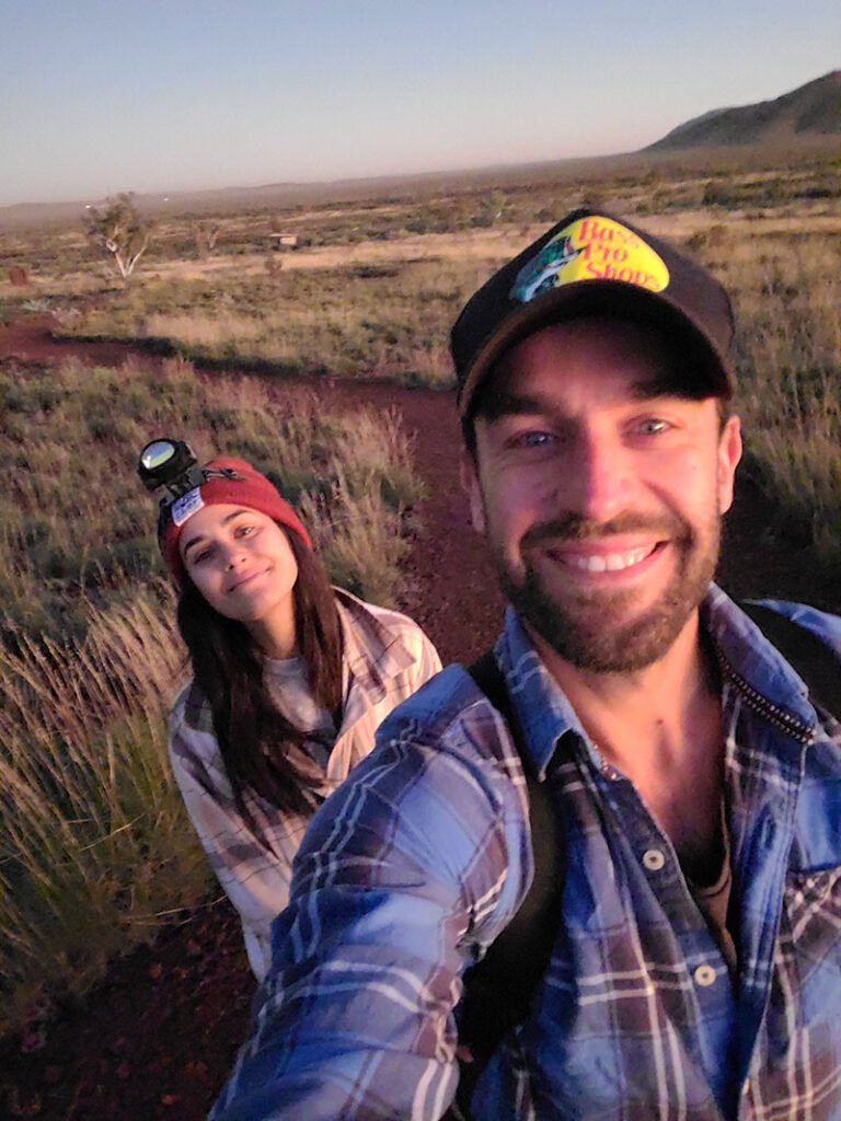
With zero artificial light, which of course makes stargazing an absolute treat, we relied on maps and squinted vision to find our way out of the camping area and on the long winding dirt road to Mount Bruce. It’s a simple 4WD track but keeping your eyes peeled for kangaroos is a must, even if your eyes haven’t been pried open yet by your first cuppa. Yessir, hitting the snooze button cost me as I’d had no time to brew a coffee before setting off on the dirt track from Dales Campground to Mount Bruce.
45 minutes of careful driving and we were at the trailhead, headtorches donned and water bottles in hands.
There’s an ominous feeling when being the only hikers on a foreign trail in the early morning. The crickets, the early morning squawks of parrots, the mildew and the cold air. We loved it.
Breaking a sweat before the incline
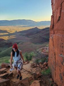
The flats were impeccably beautiful as more terrain came into view with first horizon light. This is the Marandoo View trail (Class 2), the first of the three trail options. It twists and takes you on a few gentle gradients. The shoulders of distant mountain ranges show off their beautiful layers and while you’d expect little colour from the plantlife in this sundrenched country, it teems with green and diverse fauna. The spinifex, acacia trees, eucalypts and occasional flowers greet you at many parts of the trail.
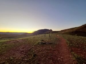
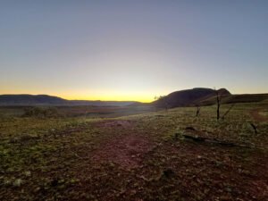
The last place you’d expect to think of out here is the Scottish Highlands, but for multiple sections of the early part of the hike, that’s what entered my mind. The sole narrow track was like a conveyor belt to gold, ours sending us straight into the growing flames of the sun.
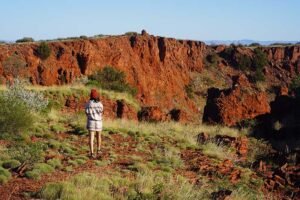
The sky looked like bruised skin, purples and oranges swimming together in the dome above, and with the frost on the and mildew melting away, we knew the heat was en route. We hit the viewpoint for Marandoo iron ore mine and the distant clunks of mining company machinery hit our ears.
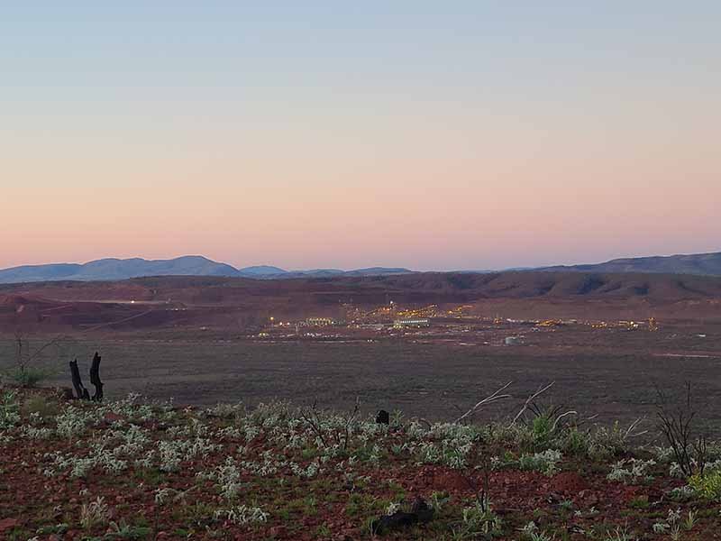
‘Yuck,’ Laura proclaimed. I was inclined to agree. Fellow hikers had made their frustration visible by marring the Rio Tinto sponsored plaque at the viewpoint. One graffitist had a good nickname for the operation: Marandoo Eye Sore. Indeed it was.
We were now on the Honey Hakea Track (Class 3) and had about a kilometre until the next vantage point. The gradient became far steeper towards the end of it, and the sun had all but made its way above the horizon. Sweat had risen from our pours too. This was the first reminder that it wouldn’t be cakework marching to the top.
Heart in the throat
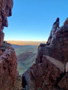
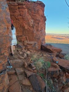
The dirt trail had turned to a very rocky one, and with that we found ourselves scrambling in certain sections.
Chain is bolted to the red cliff faces, a very much needed hiking aid for the pulse-pounding sections. You can imagine the trail planners almost begging you to watch your footing in this part of the hike. The sides of Laura’s size-five shoes were all but hanging over the edges a lot of the time. Our only preparation was charging a few hiking trails near Perth, which were far less challenging than Mount Bruce.
Laura and I travelled extensively throughout Canada and have lost count of the hikes we’ve done together. I’ll take on nearly any route on any summit, but there’s something about steep inclines and sudden drops that put my heart in my throat. I had one or two such instances, but to be honest, this just added to the experience. And look, I was perhaps being a little boyish by scooching one foot too close to the edge on certain occasions. Even a beginner hiker will do fine if safety is their number one priority. Stick to the trail, use the trail aids and watch where you’re walking.
The summit
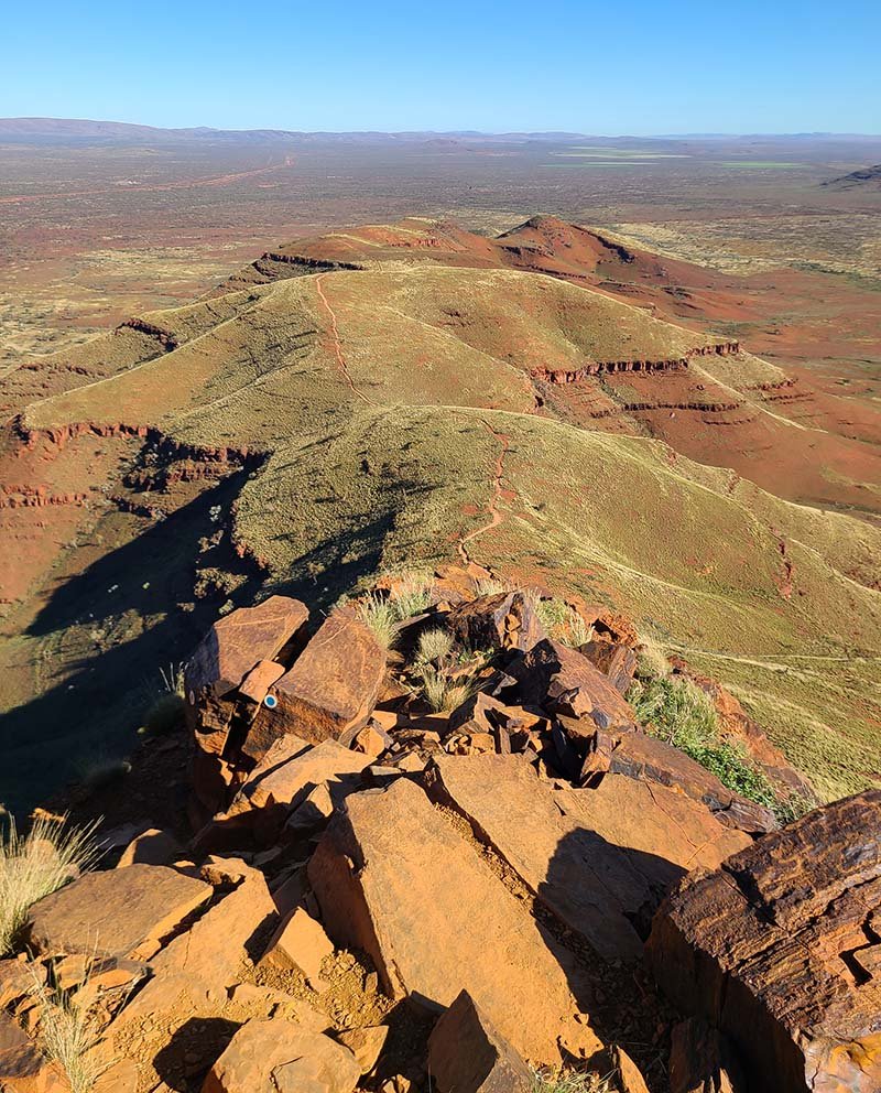
Taking stock of the kilometres we’d achieved, it was incredible to see the spine we’d hiked over. Hats off to the trail designers, as the road to get here was the perfect blend of challenge, beauty and reward.
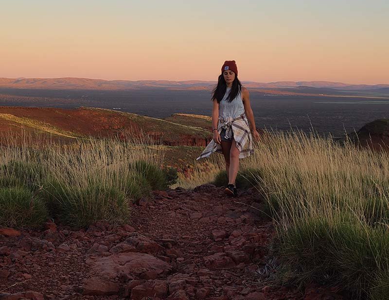
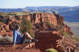
A final push led us to the top, sucking breath and letting the icy easterly breeze smack our damp bodies. Smiles all round, the mission so, so worthwhile. Being this high up, this early, gave you that sense that you got a whole nother day in the calendar year than everyone else. And it wasn’t even 10am. We swallowed the view, enjoying the shadows of spinifex and bright green flora bend over the ochre ground.
Before getting the camera out, we sat on the edge of one of the many viewing points and just marvelled at the beauty of the land. Man, what a place. There was such a spiritual aspect to Karijini, I’d even heard anti-‘woo woo’ people say the same thing. The wind came in gusts, now the only thing in our ears as our pulses chilled out.
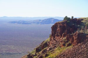
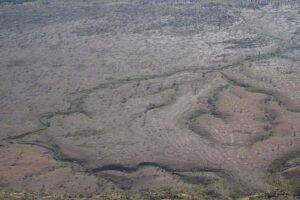
I was astounded at the blend and the contrast of different vegatations when looking down at the vast valley. Turns out, thousands of years of fire-stick farming (an ancient method of controlled burning) shaped the natural landscape of the area and the vegetation around Punurranha. The dried streams ran like arteries beneath the land’s red skin. A barrage of mountains all around us, we were hugged by the natural landscape that you couldn’t confuse with any other part of the world.
The peak is incredibly unique because it’s just so big. We spent over an hour up there, eating lunch but also exploring. The photo opportunities are of course endless, as are the number of comments about the unreal scenery.
Soon, the summit was behind us, and we reached the carpark after another hour and half on foot. Our jelly legs caught a break in the front seats of the Pajero, using the once-off cell reception to catch up on news back in Perth, simultaneously catching our breaths.
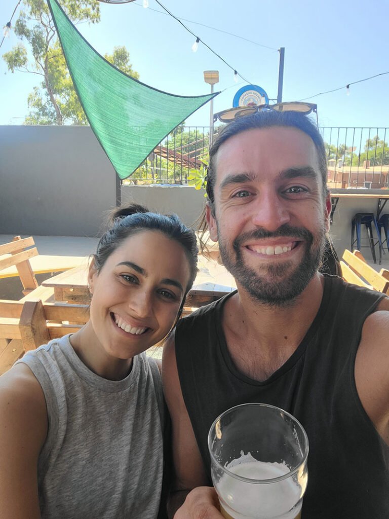
I’d known we’d had to refuel before setting off to Exmouth in a few days, and as the clock hadn’t hit midday yet, it called for a half-hour drive to the nearest point of civilisation. I might’ve missed the coffee that morning, but I didn’t miss out on the freshly poured pint in Tom Price.
Mount Bruce FAQS
Where is Mount Bruce?
Mount Bruce (Punurrunha) is in Karijini National Park, Western Australia, about 40km west of the Dales Gorge area. It’s the second-highest peak in WA and sits near the Marandoo mine site, just off Karijini Drive.
How long does it take to hike Mount Bruce?
The full summit hike is around 9km return and took us 5 hours (with a long visit at the summit). Depending on fitness levels and conditions, allow anywhere from 3 to 5 hours. If you’re after something shorter, there’s a midway viewpoint (Honey Hakea Track) that takes about 3 hours return or a quick 500m walk to the Marandoo mine lookout.
Can you drive up Mount Bruce?
No, there’s no vehicle access to the summit. You’ll need to park at the Mount Bruce trailhead (accessible via a 3km unsealed road off Karijini Drive) and hike from there.
Is there mining in the Mount Bruce area?
Yes, there is—the Marandoo minesite. Unfortunately, the government carved out a piece of national park to allow the Marandoo minesite (or the Marandoo Eye Sore) to exist and it obstructs an otherwise perfect view throughout the hike.
Ready for your next adventure? Check out our huge range of Adventure Guides for all the inspiration you’ll need for your next outdoor experience in WA.